Home
About
Mission
What We Do
Partners
Projects
Officers
Calendar
Events Gallery
Suggestions & Comments
Contact
Join Now
Collection
Document Archive
Photo Galleries
Video Presentations
Map Gallery
IGS Presentations
IGS Member Genealogies
Stories, Narratives & Histories
Newsletter
Submissions
Resources
IGS Genealogy 101
Genealogy Web Sites
Native Genealogy
Recommended Reading
How to Use Our Website
Site Map
Ask a Researcher
Zoom Meeting
News

Iroquois Genealogy Society

Home
About
Mission
What We Do
Partners
Projects
Officers
Calendar
Events Gallery
Suggestions & Comments
Contact
Join Now
Collection
Document Archive
Photo Galleries
Video Presentations
Map Gallery
IGS Presentations
IGS Member Genealogies
Stories, Narratives & Histories
Newsletter
Submissions
Resources
IGS Genealogy 101
Genealogy Web Sites
Native Genealogy
Recommended Reading
How to Use Our Website
Site Map
Ask a Researcher
Zoom Meeting
News
Cattaraugus Territory 1878

Cattaraugus Territory 1878

Map of the Cattaraugus Territory of the Seneca Nation 1878

Cattaraugus Territory 1890

Cattaraugus Territory 1890

Cattaraugus Territory, Seneca Nation 1890

Allegany Territory 1890

Allegany Territory 1890

Allegany Territory, Seneca Nation 1890

Tonawanda Territory 1890

Tonawanda Territory 1890

Tonawanda Territory 1890

Onondaga Territory 1890

Onondaga Territory 1890

Onondaga Territory 1890

St. Regis Territory 1890

St. Regis Territory 1890

St. Regis Territory 1890

The Five Indian Nations of Canada 1747

The Five Indian Nations of Canada 1747

The Five Indian Nations of Canada 1747 by Cadwallader Colden

Kane-audea Territory, Seneca Nation September 3rd 1798

Kane-audea Territory, Seneca Nation September 3rd 1798

Kane-audea Territory, Seneca Nation September 3rd 1798

Squawky-hill Territory, Seneca Nation September 10 1798

Squawky-hill Territory, Seneca Nation September 10 1798

Squawky-hill Territory, Seneca Nation September 10 1798

Canawagus Territory, Seneca Nation September 30 1798

Canawagus Territory, Seneca Nation September 30 1798

Canawagus Territory, Seneca Nation September 30 1798

Gardeau Territory, Seneca Nation September 10 1798

Gardeau Territory, Seneca Nation September 10 1798

Gardeau Territory, Seneca Nation September 10 1798

Big-tree and Little-Beards Town, Seneca Nation September 24 1798

Big-tree and Little-Beards Town, Seneca Nation September 24 1798

Big-tree and Little-Beards Town, Seneca Nation September 24 1798

Map of the Township of Carrollton, New York, 1869

Map of the Township of Carrollton, New York, 1869

Map of the Township of Carrollton, New York, 1869

Map of Allegany and Limestone, New York, and surrounding areas, 1869

Map of Allegany and Limestone, New York, and surrounding areas, 1869

Map of Allegany and Limestone, New York, and surrounding areas, 1869

Maps of Cold Spring, Carrollton, and Steamburg, New York, 1869. Maps include Steamburg and Carrollton business directories.

Maps of Cold Spring, Carrollton, and Steamburg, New York, 1869. Maps include Steamburg and Carrollton business directories.

Maps of Cold Spring, Carrollton, and Steamburg, New York, 1869. Maps include Steamburg and Carrollton business directories.

Map of Portville, New York and the township of Salamanca, New York, 1869. Maps include corresponding business directories.

Map of Portville, New York and the township of Salamanca, New York, 1869. Maps include corresponding business directories.

Map of Portville, New York and the township of Salamanca, New York, 1869. Maps include corresponding business directories.

West Part of Collins [Village]; Collins [Township] Erie County Atlas 1880 F.W. Beers & Co.

West Part of Collins [Village]; Collins [Township] Erie County Atlas 1880 F.W. Beers & Co.

West Part of Collins [Village]; Collins [Township] Erie County Atlas 1880 F.W. Beers & Co.

Farnham Station Brant [Village]; Brant [Township]; Brant Center [Village]

Farnham Station Brant [Village]; Brant [Township]; Brant Center [Village]

Farnham Station Brant [Village]; Brant [Township]; Brant Center [Village] 1880 Beers Atlas

Country of the Five Nations

Country of the Five Nations

Country of the Five Nations

Map of the Province of New York 1771

Map of the Province of New York 1771

Map of the Province of New York 1771 also known as the Guy Johnson Map

Six Nations Homeland Map

Six Nations Homeland Map

Six Nations Homeland Map

Captain Snows Sketch of the Country 1754

Captain Snows Sketch of the Country 1754

Captain Snows sketch of the Country drawn from his personal knowledge and accounts drawn from indian traders.

Bonne Camp Map 1749

Bonne Camp Map 1749

Bonne Camp Map 1749

Land of John O' Bail

Land of John O' Bail

Land of John O' Bail

Robert Morris Purchase, 1804

Robert Morris Purchase, 1804

Robert Morris Purchase, 1804

Kent Map, 18th Century Indian Towns Pennsylvania.

Kent Map, 18th Century Indian Towns Pennsylvania.

Kent Map, 18th Century Indian Towns Pennsylvania.

Buffalo Creek Territory 1842

Buffalo Creek Territory 1842

Buffalo Creek Territory 1842

Seneca Territory 1797

Seneca Territory 1797

Seneca Territory 1797

Five Nations and Mission Sites 1656-1684 from book by John S. Clark 1879

Five Nations and Mission Sites 1656-1684 from book by John S. Clark 1879

Five Nations and Mission Sites 1656-1684 from book by John S. Clark 1879

Morris Map 1800

Morris Map 1800

Morris Map 1800

Guy Johnson Map 1771

Guy Johnson Map 1771

Guy Johnson Map 1771

Lewis Evans Map 1755

Lewis Evans Map 1755

Lewis Evans Map 1755

Lewis Evans Map 1755-1775

Lewis Evans Map 1755-1775

Lewis Evans Map 1755-1775

Warren Almanac Map 1941

Warren Almanac Map 1941

Warren Almanac Map 1941

Denonville Map of Battle Ground near Victor, New York

Denonville Map of Battle Ground near Victor, New York

Denonville Map of Battle Ground near Victor, New York

Pouchot Map 1758

Pouchot Map 1758

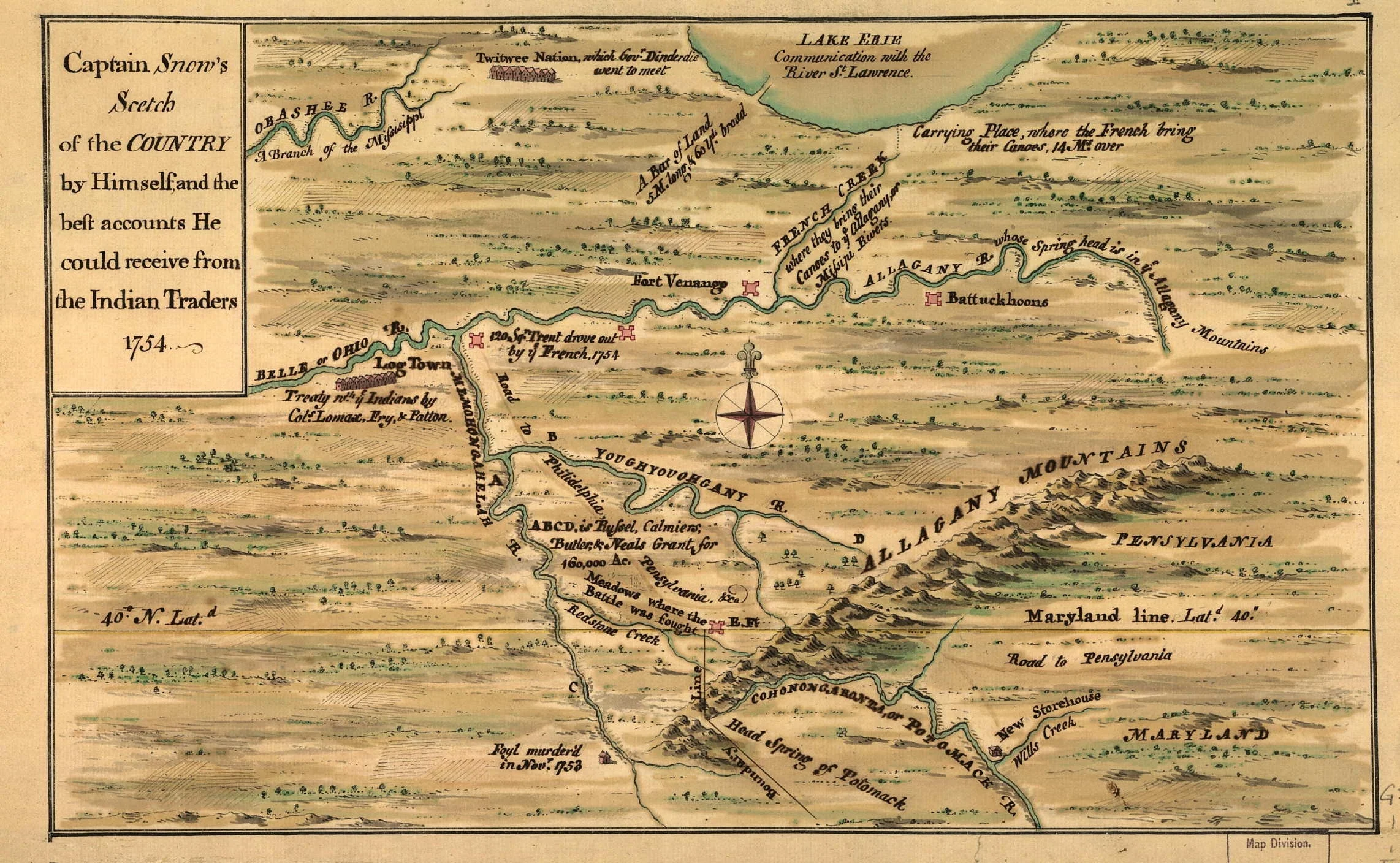
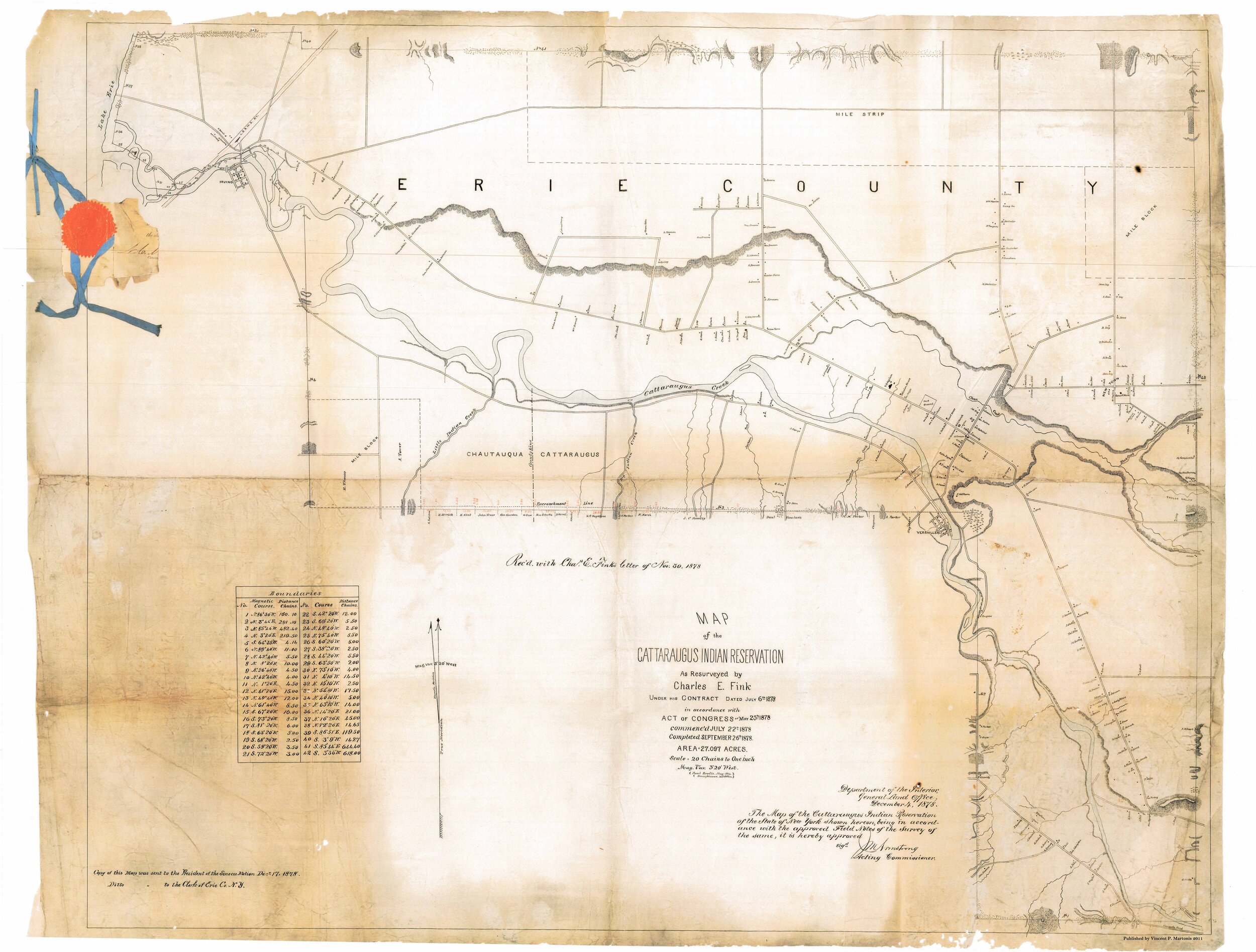
This is the map on which Ft. Standen Stone appears long before it was thought to have existed. The slice of the map enlarged above shows how inaccurate Pouchot’s conception of the territory was. As he explains in the letter below, he has not seen this country himself; his map is based on the best reports he has been able to obtain.

Captain Pouchot to Marshal de Belle Isle [Department de la Guerre, Paris]

Montreal, 14th April 1758.

My Lord,

I have handed to the Marquis de Vaudreuil a map and Memoir on the subject of the French and English frontiers, which I have drawn up on the best information I have been able to procure during my sojourn at Niagara. I had laid down, in my voyages, the course of the river from Montreal, Lake Ontario as far as Lake Erie; therefore it has an appearance of truth which correctly represents the country and is not contained in any other maps. As I have not been on the English frontier, I laid that down according to their best maps, which I again corrected on such reliable information as I have obtained. It is in sufficient detail, however, to show the interest we ought to take to prevent the English interposing obstacles in the way of the Iroquois and Loups who form a barrier. That country, my Lord, would be well worth being seen by experienced eyes, which has not as yet been the case; the well known Carrying place of Niagara is an evident proof. The most recent accounts thereof describe it as the most rugged of Alps, whilst ‘tis only a rise of ground (rideau) a little more elevated than that of Bellevue; below and above are very fine plains, as can be seen on my map.

The detail of Lake Erie, which is entirely unknown; it is, perhaps [as] navigable for large vessels as Lake Ontario. The resources of those countries, once known, would furnish opportunities of avoiding long routes and expenses, exclusive of enabling us to occupy more decided points for the security of the country.

If you have the goodness, my Lord, to signify to me that this essay might please you, I shall set about perfecting that work in order to accomplish all the objects which will possibly be required of it.

I hope, by my zeal, to deserve the kindness you have promised to honor me with, my Lord, on the recommendation of Mde de Meillian. Since our arrival in this country I have had the good fortune to be always pretty usefully employed. I constructed the Frontenac intrenchments, completed Fort Niagara and the siege of Chouaguen. I dare hope, my Lord, that you will be graciously pleased to give your attention to the good reports of me which our Generals are so good as to render.

I am, with most profound respect, my Lord,

Your most humble and most obedient servant,

Pouchot, Captn. in the Bearn regiment

Territory of American Indians circa. 1600

Territory of American Indians circa. 1600

Territory of American Indians circa. 1600

Courtesy of Carl Waldman's, "Atlas of the North American Indian" (Page 32)

Western New France 1688

Western New France 1688

A 1688 map of the region explored by La Salle. Map by Vincenzo Coronelli

CattaraugusTerritory from Map of Erie County, New York  from actual surveys

CattaraugusTerritory from Map of Erie County, New York from actual surveys

CattaraugusTerritory from Map of Erie County, New York from actual surveys

Map of Phelps and Gorham Purchase 1802–1806

Map of Phelps and Gorham Purchase 1802–1806

Map of Phelps and Gorham Purchase 1802–1806

1 2 3 4 5 6 7 8 9 10 11 12 13 14 15 16 17 18 19 20 21 22 23 24 25 26 27 28 29 30 31 32 33 34 35 36 37 38 39 40
Previous Next
Cattaraugus Territory 1878
Cattaraugus Territory 1890
Allegany Territory 1890
Tonawanda Territory 1890
Onondaga Territory 1890
St. Regis Territory 1890
The Five Indian Nations of Canada 1747
Kane-audea Territory, Seneca Nation September 3rd 1798
Squawky-hill Territory, Seneca Nation September 10 1798
Canawagus Territory, Seneca Nation September 30 1798
Gardeau Territory, Seneca Nation September 10 1798
Big-tree and Little-Beards Town, Seneca Nation September 24 1798
Map of the Township of Carrollton, New York, 1869
Map of Allegany and Limestone, New York, and surrounding areas, 1869
Maps of Cold Spring, Carrollton, and Steamburg, New York, 1869. Maps include Steamburg and Carrollton business directories.
Map of Portville, New York and the township of Salamanca, New York, 1869. Maps include corresponding business directories.
West Part of Collins [Village]; Collins [Township] Erie County Atlas 1880 F.W. Beers & Co.
Farnham Station Brant [Village]; Brant [Township]; Brant Center [Village]
Country of the Five Nations
Map of the Province of New York 1771
Six Nations Homeland Map
Captain Snows Sketch of the Country 1754
Bonne Camp Map 1749
Land of John O' Bail
Robert Morris Purchase, 1804
Kent Map, 18th Century Indian Towns Pennsylvania.
Buffalo Creek Territory 1842
Seneca Territory 1797
Five Nations and Mission Sites 1656-1684 from book by John S. Clark 1879
Morris Map 1800
Guy Johnson Map 1771
Lewis Evans Map 1755
Lewis Evans Map 1755-1775
Warren Almanac Map 1941
Denonville Map of Battle Ground near Victor, New York
Pouchot Map 1758
Territory of American Indians circa. 1600
Western New France 1688
CattaraugusTerritory from Map of Erie County, New York  from actual surveys
Map of Phelps and Gorham Purchase 1802–1806
Back to Top
Contact
Join Now
Search
Iroquois Genealogy Society, Irving, NY, 14081iroquois.genealogy@gmail.com

© 2018 Iroquois Genealogy Society. All rights reserved.

Commercial use of any images, videos, recordings, documents, databases, manuscripts or collections contained on this website is strictly forbidden without prior written consent. The material on the website is solely for research purposes.

Powered by Squarespace