View fullsize
![Cattaraugus Territory 1878]()

Cattaraugus Territory 1878
View fullsize
![Cattaraugus Territory 1890]()

Cattaraugus Territory 1890
View fullsize
![Allegany Territory 1890]()

Allegany Territory 1890
View fullsize
![Tonawanda Territory 1890]()

Tonawanda Territory 1890
View fullsize
![Onondaga Territory 1890]()

Onondaga Territory 1890
View fullsize
![St. Regis Territory 1890]()

St. Regis Territory 1890
View fullsize
![The Five Indian Nations of Canada 1747]()

The Five Indian Nations of Canada 1747
View fullsize
![Kane-audea Territory, Seneca Nation September 3rd 1798]()

Kane-audea Territory, Seneca Nation September 3rd 1798
View fullsize
![Squawky-hill Territory, Seneca Nation September 10 1798]()

Squawky-hill Territory, Seneca Nation September 10 1798
View fullsize
![Canawagus Territory, Seneca Nation September 30 1798]()

Canawagus Territory, Seneca Nation September 30 1798
View fullsize
![Gardeau Territory, Seneca Nation September 10 1798]()

Gardeau Territory, Seneca Nation September 10 1798
View fullsize
![Big-tree and Little-Beards Town, Seneca Nation September 24 1798]()

Big-tree and Little-Beards Town, Seneca Nation September 24 1798
View fullsize
![Map of the Township of Carrollton, New York, 1869]()

Map of the Township of Carrollton, New York, 1869
View fullsize
![Map of Allegany and Limestone, New York, and surrounding areas, 1869]()

Map of Allegany and Limestone, New York, and surrounding areas, 1869
View fullsize
![Maps of Cold Spring, Carrollton, and Steamburg, New York, 1869. Maps include Steamburg and Carrollton business directories.]()

Maps of Cold Spring, Carrollton, and Steamburg, New York, 1869. Maps include Steamburg and Carrollton business directories.
View fullsize
![Map of Portville, New York and the township of Salamanca, New York, 1869. Maps include corresponding business directories.]()

Map of Portville, New York and the township of Salamanca, New York, 1869. Maps include corresponding business directories.
View fullsize
![West Part of Collins [Village]; Collins [Township] Erie County Atlas 1880 F.W. Beers & Co.]()
![West Part of Collins [Village]; Collins [Township] Erie County Atlas 1880 F.W. Beers & Co.](https://images.squarespace-cdn.com/content/v1/5b9337ac75f9ee5fa8f6f2cd/1539738679741-974O5ATCZFR6T80ZGK53/West+Part+of+Collins+%5BVillage%5D%3B+Collins+%5BTownship%5D+Erie+County+Atlas+1880+F.W.+Beers+%26+Co..jpg)
West Part of Collins [Village]; Collins [Township] Erie County Atlas 1880 F.W. Beers & Co.
View fullsize
![Farnham Station Brant [Village]; Brant [Township]; Brant Center [Village]]()
![Farnham Station Brant [Village]; Brant [Township]; Brant Center [Village]](https://images.squarespace-cdn.com/content/v1/5b9337ac75f9ee5fa8f6f2cd/1541117652437-OV3DRYMB7714XQ8RM0JZ/Farnham+Station+Brant+%5BVillage%5D%3B+Brant+%5BTownship%5D%3B+Brant+Center+%5BVillage%5D.jpg)
Farnham Station Brant [Village]; Brant [Township]; Brant Center [Village]
View fullsize
![Country of the Five Nations]()

Country of the Five Nations
View fullsize
![Map of the Province of New York 1771]()

Map of the Province of New York 1771
View fullsize
![Six Nations Homeland Map]()

Six Nations Homeland Map
View fullsize
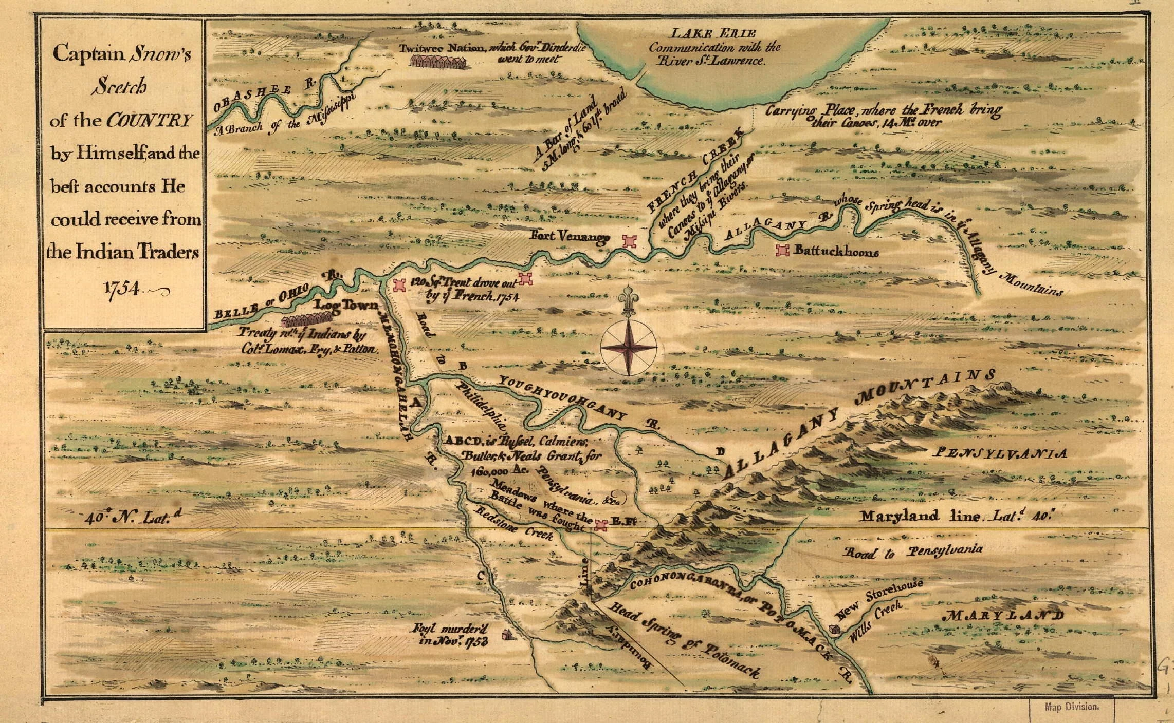
![Captain Snows Sketch of the Country 1754]()

Captain Snows Sketch of the Country 1754
View fullsize
![Bonne Camp Map 1749]()

Bonne Camp Map 1749
View fullsize
![Land of John O' Bail]()

Land of John O' Bail
View fullsize
![Robert Morris Purchase, 1804]()

Robert Morris Purchase, 1804
View fullsize
![Kent Map, 18th Century Indian Towns Pennsylvania.]()

Kent Map, 18th Century Indian Towns Pennsylvania.
View fullsize
![Buffalo Creek Territory 1842]()

Buffalo Creek Territory 1842
View fullsize
![Seneca Territory 1797]()

Seneca Territory 1797
View fullsize
![Five Nations and Mission Sites 1656-1684 from book by John S. Clark 1879]()

Five Nations and Mission Sites 1656-1684 from book by John S. Clark 1879
View fullsize
![Morris Map 1800]()

Morris Map 1800
View fullsize
![Guy Johnson Map 1771]()

Guy Johnson Map 1771
View fullsize
![Lewis Evans Map 1755]()

Lewis Evans Map 1755
View fullsize
![Lewis Evans Map 1755-1775]()

Lewis Evans Map 1755-1775
View fullsize
![Warren Almanac Map 1941]()

Warren Almanac Map 1941
View fullsize
![Denonville Map of Battle Ground near Victor, New York]()

Denonville Map of Battle Ground near Victor, New York
View fullsize
![Pouchot Map 1758]()

Pouchot Map 1758
View fullsize
![Territory of American Indians circa. 1600]()

Territory of American Indians circa. 1600
View fullsize
![Western New France 1688]()

Western New France 1688
View fullsize
![CattaraugusTerritory from Map of Erie County, New York from actual surveys]()

CattaraugusTerritory from Map of Erie County, New York from actual surveys
View fullsize
![Map of Phelps and Gorham Purchase 1802–1806]()

Map of Phelps and Gorham Purchase 1802–1806
